mapGPSdata
Email:
MapGPSdata is software that lets you find, capture, place, plot and enter Latitude and Longitude (lat/long) precise location coordinates onto a map, such as a Google map, and add some additional information about the location and save it all to a Microsoft Access database.
We wrote this software because we couldn’t find a program to do what we wanted, so we wrote our own. Sure there is software out there and it can do some very clever stuff. Great if you want to plot the position of underground water pipes or telephone cables. Great if you want to add boundaries around plots of land or find the area of a field. Great if you have high demands and a deep wallet but not if you want simplicity, basic functionality and value for money.
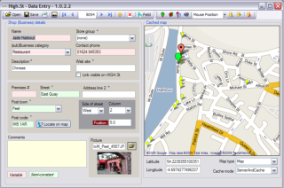
MapGPSdata was written to support www.High.St and so it is thoroughly proven in a real world application. Information, including names, descriptions, addresses, telephone numbers, web addresses, etc is collected and entered into one part of the window and the map is displayed in another part. Markers can be placed on the map at the appropriate position and the lat/long calculated from the position of the lollipop. Alternatively, the lat/long can be captured from a GPS device, a GPS equipped camera, data logger, GPS watch, a Garmin or Magellan unit, etc and fed into the database. The marker is then placed at the lat/long position. The program is very helpful so if no lat/long is available, it will centre the map on the city/town or post code/zip.
This software program will be useful to schools, educational institutions, local authorities, businesses, photographers, and anyone who wants to associate data with a location, map displays and keep this together in a database for future recall and reference.
We are considering releasing this software and it would be great to hear from you about the features you need and your expectations from such a program - and how much you would be prepared to pay. We cannot promise to meet all requirements, or we would end up with an unaffordable solution, but we will consider all your comments and do what we can to make the program as versatile as possible.